
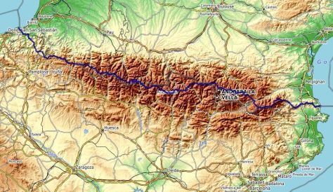
The way, accomodation, resupply, daily stages, GPS track of the hike through Pyrenees on the HRP (Haute Route Pyrénéenne – High Route of Pyrenees).
Hiking through the Pyrenees on the HRP
There is not one HRP route but multiple options, trying to stay as close to the summits either on the north or the south slope. I joined the HRP coming from Massif Central at the heights at Canigou. Then, among my options :
– hiking through the Carlit. It is quite classic rather than crossing Cerdanya at Puigcerdà.
– Ariège rather than the Andorran side after l’Hospitalet-près-l’Andorre. I do not know this part of the Pyrenees and it’s wilder than the way by Arcalís (which seems more used by hikers on the HRP)
– the southern slope of the Maladeta. Again, I do not know this part. This is where I did my 3000 from my HRP, the Vallibierna and its impressive Paso del Caballo. Then, I continued via Estós at the foot of the Posets and switch back to the French side at the Cirque de Barroude. The classic option is the northern slope of the Maladeta then passing by the Portillon refuge.
– after the Ossau, I took the GR10 via the Chemin de la Mâture (unfortunately closed) and the village of Lescun. I have already crossed the Pyrenees via the Col des Moines, Somport to Candanchú which is not the case for the variant
via the GR10.
In addition, I hiked from the Mediterranean sea to the Canigou Massif at the end of September just to have done the full HRP. For this last section, I started from Cerbère (rather than Banyuls) to complete with Lauterbourg and Hendaye (and Menton after crossing Italy) my routes to the ends of France.
For a hike through the Pyrenees on the Spanish side with the 3 highest peaks (Aneto, Posets, Mont Perdu) on the route, see the page Pyrenees south side.
To extend the HRP to the west, see the page Cantabrian Mountains. This hike from the Mediterranean sea to Portugal is a superb mountain way of 1500km with 85000m of elevation gain.
Internet website :
Cicerone published a guide book in english for HRP.
The hrp-info.fr site provides information on this trek. The various french guide books are presented there.
In French, on «les blogs de Franck», the page about HRP is very rich and interesting.
For all France, the site gites-refuges.com is useful for information on huts and “gîtes d’étape” and that Refuges.info for huts and shelters.
Specifically for the Pyrenees, the site Pyrenees-refuges.com is very complete on this massif. It’s possible to download the gps position of all the “cabanes” and “refuges”.
Lexicon :
Bivouac: wild camping, usually according to French regulation, in a small tent (where you can’t standing) and pitched only for the night.
Abri: shelter. It’s unclosed (no door, some with just a roof) quite similar to those on the Appalachian Trail.
Cabane: small hut or shelter. It has a door. Some “cabanes” are occupied in summer by shepherds and open the rest of the year.
Refuge non gardé : unattended hut. Unlike a simple “cabane”, usually there are beds with mats.
Refuge: hut. You sleep in dorms, they can provide meals. Some of them even have showers.
Gîte d’étape: It’s like a refuge (or hostel) but accessible by road. You sleep in dorms (some have also bedrooms), they can provide meals. You will find “gîtes d’étape” on the main hiking trails.
Useful informations :
Accomodation and resupply :
See the board below. Wild camping (bivouac) : see below for Spain and the special rules in the natural parks.
To resupply, the possibilities on the central part of the chain are limited. Nothing between Superbolquère and Benasque (at the Aneto campsite) except a small grocery store in L’Hospitalet-près-l’Andorre (and a bakery). Then you have to reach Gavarnie to find a grocery store and then in Etsaut/Borce/Lescun. It is of course possible to descend into the valleys if needed (Salardu, Parzan, possibility to arrange it with the gîte d’étape de Mounicou). There are also huts that offer picnics and meals.
Accommodation: there are attended huts. There are also shelters. Some long sections require a tent: from the Rulhe hut to the Fourcat lake hut, from the Belagua (Ángel Olorón) hut to Roncesvalles.
Bivouac in Spain : The regulations concerning the bivouac and wild camping is a competence of the autonomous communities with specific rules in certain natural areas.
Catalonia: Wild camping is prohibited within 1km of a campsite or a village.
Aragon: Wild camping is prohibited with fines in case of violation but this does not seem to concern the bivouac (see for example below the rules in the natural parks of this region)
Navarre: Camping is authorized except in nature reserves and in the immediate vicinity of rivers, springs and fountains, paths and more than 1km from the campsite.
Basque Country: The bivouac can be authorized by the municipalities.
Water : overall this is not a problem. It may be necessary to descend to cayolars (shepherd hut) on the Basque ridges after the Belagua refuge.
Conditions (weather, snow) : I did my HRP at the end of summer (from 17/8 to 7/9 ). By my way, there was no snowfield left (there was a very small one that could be avoided below the port of Cambalès after the Wallon refuge). Passing through Vallibierna to the south of Aneto, I did not go through the Mulleres pass or the Litérole pass (where a snowfield can persist at the end of summer).
The weather in the Pyrenees is unstable, as in all the mountains, with perhaps the specificity of being between the ocean and the Mediterranean, therefore subject to significant variations in hot and cold air currents. It is common to have bad weather on the north side and beautiful on the south side, which can affect the way you choose.
Network : it is rare not to be able to have network more than one day. The longest part where I didn’t have one was between Gavarnie and Pourtalet.
Equipment : see the introduction page of my Grande Traversée de la France for the list.
Natural parks :
Parc naturel régional des Pyrénées Catalanes : wild camping is prohibited in all nature reserves and in the classified sites of the regional natural park of the Catalan Pyrenees. The bivouac is authorized around the refuges and along the GR.
Parc naturel régional des Pyrénées Ariégeoises : no specific regulations.
Parc Nacional d’Aigüestortes i Estany de Sant Maurici : bivouac prohibited even near the huts.
Parque Natural Posets Maladeta : bivouac authorized only at more than 2000 meters above sea level and more than 500 meters from a refuge.
Parc national des Pyrénées : bivouac authorized more than one hour’s walk from a road access, between 7 p.m. and 9 a.m.
Trail marks : generally markings or cairns but the HRP is on certain parts off marked trails. The parts between the Rulhe refuge and the Fourcat lake refuge and towards Alós d’Isil are more difficult to follow.
The other parts of my Grande Traversée of France :
– Grande Traversée of Vosges (GR5)
– Grande Traversée of Jura (GR5)
– Grande Traversée of the Alps – North part (GR Balcon du Léman, GR5) then south of Ecrins, Dévoluy, Drôme
– From Alps to Pyrénées (GR4, GR7, GR36)
GPS track- maps :
It is easy to find GPS tracks from HRP on track sharing sites. It is also possible to download it on the site hiking.waymarkedtrails.org.
For topographic maps of the French National Institute of Geography (IGN), the easiest is Geoportail.
To draw a track, the sites IGN Rando and Brouter.de allow to draw following the existing ways and trails.
Subtitle in english – italiano – español
When I’m on my way, I’m using the Iphigénie application. With it, you can have offline IGN topographic maps (both for France and Spain). It’s also possible to send beacons of my position (if there is network); this can be reassuring on certain occasions.
GPS track of my HRP:
The GPS track below was reconstructed on my return. In all cases, the reality on the ground should be privileged. See additional information for each stage in the board below and especially on difficult parts.
Link to download the GPX track :
The others ways in Pyrenees described :
North-South trails on old cross-border paths, Argelès/Mer-Barcelone, hike through south side, are described in the page Hiking through Pyrenees

The stages :
From the Mediterranean sea to the Canigou – section hiked after the end of the Grande Traversée de la France in order to have completed a full HRP during the year. Departure from Cerbère (rather than Banyuls) to complete with Lauterbourg and Hendaye (and Menton after crossing Italy) my routes to the ends of France.
See the track Openrunner for the part from Cerbère to Canigou
| De Cerbère au Canigou | Km | Total km | A+ | Info |
| Cerbère | 0 | 0 | 0 | All shops. | Abri Jordana | 12 | 12 | 1060 | Small stone shelter – source below (marked on OpenTopoMap maps) . | Col de Banyuls | 4 | 16 | 100 | Cabane – no water. | Jonction GR10 | 4 | 20 | 630 | Cabane Tomy sous le Puig de Sallfort. | 01 Cerbère – Puig de Sallfort | Départ de Cerbère vers 12h30. Chemin balisé du Cap Cerbère par les crêtes jusqu’au minuscule “refuge” Tomy (abri sous les rochers du Pic – 1 à 2 couchages maximum). De l’eau à la font Jordana sous le Puig d’en Jordà (abri de pierre également) et source François Grand sur le GR10 sous le Puig de Sallfort. L’étape doit être redoutable par fortes chaleurs (sec et pratiquement pas d’ombre). 20km D+1790m |
| Refuge de la Tagnyareda | 9 | 29 | 440 | Cabane. Bonne source 500 mètres après. | Coll de l’Ullat | 4 | 31 | 210 | Refuge Chalet de l’Albère Tél.04 68 83 62 20. | Le Perthus | 8 | 41 | 130 | Commerces. | Las Illas | 14 | 55 | 640 | Pour le gîte communal Tél.07 76 09 65 81 (Fabien) – aire de bivouac – L’hostal des Trabucayres fait restaurant. | 02 Puig de Sallfort – Las Illas | Sur le GR10 avec quelques petites variantes (pistes et sentiers). Si la fontaine de la Maçana coulait à peine, celle de Tanyareda a un gros débit. Ensuite, l’eau ne pose pas de problème. 34km D+1400m. |
| Refugi les Salines | 5 | 60 | 550 | Non gardé. Bonnes fontaines. | Amélie-les-Bains | 12 | 72 | 450 | Tous commerces – Camping Amélia Tél : 04 68 39 00 49 – Nombreux hôtels. |
Refuge de Batère | 15 | 87 | 1370 | Refuge de Batère. Tél.+33 6 88 04 41 69 |
03 Las Illas – Batera | Sentiers balisés sans problèmes particuliers hors GR10 la plupart du temps. 32km D+2370m |
| Cabane de l’Estanyol | 5 | 92 | 300 | Cabane | Cabane de Pinatelli | 2 | 94 | 240 | Prades | 25 | 119 | 710 | 04 Batera – Prades | Par le GR10 jusqu’à la jonction avec ma HRP à Ras de Prat Cabrera puis descente par un sentier balisé via les cabanes de Prat Cabrera, la Mouline et Mas Malet. J’ai ensuite rejoint Prades par le Coll del Forn, Clara, le col de la Creu et la Costa de Clara. 32km D+1270m |
| Pyrénées | Km | Total km | Ascent+ | Info |
| Vinça | 0 | 0 | 170 | Camping du Lac de Vinça – Hptel – All shops. |
| Espira-de-Conflent | 6 | 6 | 200 | https://www.camping-canigou.com/fr/ |
| Baillestavy | 8 | 14 | 610 | Gîte d’étape in the village above Tél : +33 6 25 73 59 25 – Bar-restaurant in the village below. |
| 56 Trilla – Baillestavy | Sur le GR36. Belles vues sur le Canigou. | |||
| Refuge des Cortalets | 12 | 26 | 1 720 | Refuge des Cortalets Tél.+33 (0)4 68 96 36 19 |
| Pic du Canigou | 4 | 30 | 560 | |
| Cabane Arago | 4 | 34 | 0 | Cabane |
| Refuge de Mariailles | 5 | 39 | 100 | Refuge de Mariailles Tél : +33 (0)4 68 05 57 99 |
| Cabane de Pla Guillem | 4 | 43 | 550 | Cabane |
| 57 Baillestavy – Pla Guillem | Sur le GR36 puis jonction avec le GR10 avant le passage par le Canigou. Descente par la raide cheminée. Du dénivelé pour cette étape. | |||
| Cabane Portella de Rotja | 10 | 53 | 300 | Cabane |
| Vallter 2000 | 7 | 60 | 150 | Bar-restaurant |
| Refuge Ulldeter | 2 | 62 | 130 | Refugi Ulldeter Tél.+34 972 19 20 05 |
| Eyne | 19 | 81 | 900 | Gîte Cal Pai Tél.06 08 82 00 99 – grocery store, boulangerie |
| 58 Pla Guillem – Eyne | Le GRP Ronde du Canigou, puis le GR11 espagnol sur des crêtes herbeuses et faciles sont bien balisés. Une fois laissé le GR11, la liaison jusqu’au col de Núria n’est pas balisée mais le sentier sur les crêtes est bien marqué. La descente sur Eyne ne pose pas de problème. | |||
| Col de la Perche | 4 | 85 | 90 | Hôtel Le Catalan Tél.+33 4 68 04 21 83 |
| Bolquère | 2 | 87 | 60 | Hôtel “L’ancienne auberge” Tél.+33 4 68 30 09 51 – Hôtel Le Lassus Tél.+33 4 68 30 09 75 – grocery store |
| Superbolquère | 3 | 90 | 150 | Supermarket – boulangerie – Chalet du Ticou Tél.+33 5 65 22 68 21 |
| Les Bouillouses | 9 | 99 | 400 | Hôtel Les Bones Hores Tél.+33 4 68 04 24 22 – Auberge du Carlit Tél.+33 4 68 04 22 23 |
| Cabane de Rouzet | 14 | 113 | 990 | Cabane |
| Refuge des Bésines | 6 | 119 | 280 | Refuge des Bésines Tél.+33 9 88 77 35 28 – cabanes before the refuge (Coume d’Anyell) and before and after the dam |
| 59 Eyne – Refuge des Bésines | J’ai récupéré le GR10 mais suis passé par Superbolquère me ravitailler pour rejoindre ensuite à nouveau le GR10. Puis des Bouillouses, passage par le Carlit (montée finale raide). Paysages superbes. | |||
| L’Hospitalet-prés-l’Andorre | 7 | 126 | 90 | Camping Tél.+33 5 61 05 21 10 – Gîte d’étape L’Hospitalité Tél.+33 6 74 87 05 05 – Hôtel du Puymorens Tél.+33 5 61 05 20 03 – camping La Porte des Cimes Tél.+33 5 61 05 21 10 – small grocery store – boulangerie |
| Refugi de Juclar | x | x | x | Refugi de Juclar Tél.+376 67814571 |
| Refuge du Rulhe | 13 | 139 | 1 240 | Refuge du Rulhe Tél.+33 6 74 24 50 71 |
| 60 Refuge des Bésines – Vallon Rau de la Coume de Varilhes | À partir de L’Hospitalet-prés-l’Andorre, GR68, 67 et 66. Le sentier est plus caractéristique de la HRP, moins fréquenté, des passages sur rochers. Paysage minéral typique des Pyrénées avec une myriade de superbes lacs. Le chemin est balisé et facile à suivre. | |||
| Refuge du Fourcat | 26 | 165 | 2 100 | Refuge de l’Etang Fourcat Tél.+33 5 61 65 43 15 |
| 61 Vallon Rau de la Coume de Varilhes – Refuge de l’étang de Fourcat | Étape très HRP, difficile et peu fréquentée à déconseiller par mauvais temps. Le sentier par endroit n’est pas visible. Il est pratiquement non balisé sur toute cette section (des cairns sur certaines parties). Beaucoup de parties sur rochers et de courtes sections raides. Beaucoup de passages à flanc en dévers et chemin qui monte et descend en permanence. | |||
| Gîte de Mounicou | 11 | 176 | 350 | Gîte d’étape du Mounicou Tél.+33 6 22 24 60 02 (possibility to buy in advance food) |
| Refugi Certascan | 18 | 194 | 1 890 | Refugi Certascan Tél.+34 647 96 19 46 |
| 62 Refuge de l’étang de Fourcat – Refugi de Certascan | Sentier encore difficile jusqu’à l’étang du Picot (rochers, quelques passages avec chaînes) mais balisé. Ensuite, bon sentier. De Marc en Espagne et jusqu’au Refugi de Certascan, bon sentier et balisé GR. | |||
| Refugi Mont-Roig | 14 | 208 | 1 060 | Refugi Mont-roig “Enric Pujol” Refuge non gardé |
| Alós d’Isil | 13 | 221 | 450 | Gîte d’étape (gestion libre) – contacter le refuge del Fornet Tél.618 14 67 05 |
| 63 Refugi de Certascan – Alós d’Isil | Jusqu’au Refuge de Mont Roig bon sentier balisé, ensuite sentier avec cairns. Toujours une multitude de beaux lacs. | |||
| Refugi d’Airoto | 7 | 228 | 1 150 | Refuge non gardé |
| Port de la Bonaigua | 9 | 237 | 530 | Bar-restaurant |
| Refugi de Saboredo | 6 | 243 | 500 | Refugi de Saboredo Tél.+34 973 09 09 14 |
| 64 Alós d’Isil – Refugi de Saboredo | La montée d’Alós d’Isil jusqu’aux granges Bordes de Moredo n’est pas évidente à trouver. Ensuite sentier avec cairns pas toujours facile à suivre jusqu’à l’Estany de Garrabea. Ensuite bon sentier. Toujours de beaux paysages. | |||
| Refugi de Colomèrs | 4 | 247 | 260 | Refugi de Colomèrs Tél.+34 973 253 008 |
| Refugio de la Restanca | 7 | 254 | 520 | Refugi de Restanca Tél.+34 608 03 65 59 |
| Refugio de Conangles | 15 | 269 | 660 | Refugi de Conangles Tél.+34 696 64 98 71 |
| 65 Refugi de Saboredo – Refugi de Conangles | Pas de problèmes pour suivre le chemin. Il est bien balisé et assez fréquenté. Superbes paysages. | |||
| Cabane d’Anglios | 8 | 277 | 840 | Cabane |
| Refugio Cap de Llauset | 3 | 280 | 290 | Refugio Cap de Llauset Tél.: +34 974 120 400 |
| Refugio de Pescadores | 6 | 286 | 320 | Refuge non gardé |
| Plan de Senarta | 7 | 293 | 150 | Camping |
| Puente San Jaime (route de Bénasque) | 3 | 296 | 70 | Camping Ixeia Tél.+34 962 28 00 19 – Camping Aneto Tél.+34 974 55 11 41 – grocery store in the camping – Hostal Parque Natural Tél.+34 974 34 45 84 |
| 66 Refugi de Conangles – Vallée de Benasque | Après le refuge de Conangles, j’ai choisi de laisser la voie la plus classique de la HRP qui passe par le col des Mulleres puis celui de Litèrole pour basculer côté français. J’ai préféré le versant sud du massif de la Maladeta que je ne connaissais pas. Il est possible de suivre tout le long le GR11. Je suis passé par le Vallibierna. Le passage sur l’arête est impressionnant (voir les vidéos sur le paso del caballo). À déconseiller si sujet au vertige (les prises sont plutôt bonnes). La descente de l’autre côté se fait sur un grand pierrier assez désagréable. Belles vues sur le versant sud de la Maladeta. | |||
| Refugio de Estós | 9 | 305 | 680 | Refugio de Estós Tél.+34 974 344 515 |
| Cabaña de Añes Cruces | 7 | 312 | 730 | Cabane |
| Cabane Puyarueso | 2 | 314 | 10 | Cabane |
| Refugio de Viadós | 2 | 316 | 0 | Refugio de Viadós Tél.+34 974 34 16 13 – Camping el Forcallo Tél.+34 974 33 75 51 – cabane Es Plan |
| Paso de los Caballos | 10 | 326 | 920 | Cabane del Paso de los Caballos, Refugio Urdiceto (non gardé), Cabane du Col d’Ordizeto |
| Cabane de Trigoniero (Plana el Cabo) | 7 | 333 | 310 | Cabane |
| 67 Vallée de Benasque – Cabane de Trigoniero | Sur le GR11, sentier facile, sans problème. Après le col d’Urdiceto, j’ai suivi un vague sentier à flanc, avec cairns à la fin (pas de difficultés. Belles vues sur les Posets et la punta Suelza. | |||
| 68 Cabane de Trigoniero – Sortie sud du tunnel Aragnouet-Bielsa | Montée depuis le vallon où se trouve la cabane par une combe assez raide mais sans difficulté (pas vraiment un sentier). On trouve ensuite des cairns puis un balisage jusqu’à un port. Passage ensuite sur crêtes. Compte tenu du temps, je suis redescendu vers la vallée de Bielsa. | |||
| Cabane de la Vierge | 26 | 359 | 1 990 | Cabane |
| Auberge du Maillet | 3 | 362 | 10 | Auberge du Maillet Tél.+33 5 62 92 48 97 – further, cabane de Groutte |
| 69 Sortie sud du tunnel Aragnouet-Bielsa – Troumouse | La plupart de la journée sur des sentiers souvent non balisés, parfois des cairns mais faciles à suivre. Il y a trois ans, avec le beau temps, superbes paysages. Cette fois dans la brume. | |||
| Cabane d’Estaubé | 8 | 370 | 290 | Cabane |
| Refuge des Espuguettes | 7 | 377 | 680 | Refuge des Espuguettes Tél.+33 5 62 92 40 63 – un peu plus bas, cabane du plateau de Pailha |
| Refuge de Pailha | 2 | 379 | 0 | Tél.+33 6 30 41 23 92 |
| Gavarnie | 2 | 381 | 10 | Camping La Bergerie Tél.+33 5 62 92 48 41 – Gîte Oxygène Tél.+33 5 62 92 48 23 – Gîte Le Gypaète Tél.05 62 92 40 61 – Chalet “La grange de Holle” Tél.+33 5 62 92 48 77 – Sevral hotels – grocery store |
| 70 Troumouse – Gavarnie | Étape assez courte sur un bon sentier facile à suivre. Magnifiques paysages quand il fait beau… | |||
| Refuge de Bayssellance | 17 | 398 | 1 600 | Refuge de Bayssellance Tél.+33 5 62 92 40 25 |
| Refuge des Oulettes de Gaube | 5 | 403 | 110 | Refuge des Oulettes de Gaube Tél.+33 9 88 18 41 46 |
| Refuge Wallon | 9 | 412 | 600 | Refuge Wallon Tél.+33 5 62 92 64 28 |
| 71 Gavarnie – Lac de Cambalès | De Gavarnie, soit par le GR10 soit, plus directement, par le sentier qui part du pont Saint Savin et passe sur l’autre rive par rapport à la route de la vallée d’Ossoue. La vedette de la journée, c’est le Vignemale. Bon sentier facile à suivre. | |||
| Refugio Respomuso | 12 | 424 | 930 | Refugio Respomuso Tél.+34 974 33 75 56 |
| Refuge d’Arrémoulit | 7 | 431 | 480 | Refuge d’Arrémoulit Tél.+33 5 59 05 31 79 |
| Route du Pourtalet | 6 | 437 | 120 | Cabane du Caillou de Soques |
| Refuge de Pombie | 5 | 442 | 670 | Refuge de Pombie Tél.+33 5 59 05 31 78 |
| Cabane de Cap de Pount | 5 | 447 | 290 | Cabane et un peu avant cabane de Peyreget (très petit) |
| Refuge d’Ayous | 5 | 452 | 490 | Refuge d’Ayous Tél.+33 5 59 05 37 00 |
| 72 Lac de Cambalès – Refuge d’Ayous | Globalement, de bons sentiers (certaines parties proches des cols sont sur la rocaille). Le passage d’Orteig après le refuge d’Arrémoulit est un peu vertigineux (équipé d’une main courante). La vedette de la journée, c’est le Pic du Midi d’Ossau mais les paysages sont beaux tout le long. | |||
| Etsaut et Borce | 15 | 6)467 | 420 | Etsaut : Gîte La Garbure Tél.+33559348898 – bar-restaurant – Borce : Auberge de l’Ours Tél.+33559347593 – bar et petite épicerie |
| Plateau de Lhers | 9 | 6)476 | 980 | Gîte d’étape et camping de Lhers Tél.+33 5 59 34 75 39 |
| Le Lauzart | 5 | 481 | 110 | Gîte d’étape et camping du Lauzart Tél.+33 6 13 13 12 17 |
| Lescun | 1 | 482 | 70 | Gîte d’étape “La Maison de la Montagne” Tél.+33 5 59 34 79 14 – Gîte d’étape “Le Pic d’Anie” Tél.+33 5 59 34 71 54 – bar-restaurant – grocery store |
| 73 Refuge d’Ayous – Lescun | Sur le GR10, plutôt que la HRP qui passe par les stations de ski d’Astún et Candanchú. Beaux paysages, malheureusement le chemin de la mâture était fermé. Sentier facile. | |||
| Refugio de Belagua – Ángel Olorón | 19 | 501 | 1 300 | Refugio Belagua Tél.+34 623 10 73 17 |
| 74 Lescun – Port de Larrau | Bon sentier, très bien balisé côté espagnol. Vert côté Lescun puis minéral karstique et enfin crêtes herbeuses au Pays Basque | |||
| Col d’Orgambidé | 45 | 546 | 2 480 | Cabane |
| Azpegi | 2 | 548 | 60 | Refuge non gardé |
| Izandorre | 6 | 554 | 340 | Cabane |
| Roncevaux | x | x | x | Albergue – Hotels – Bars and restaurants |
| 75 Port de Larrau – Roncevaux | Passage par le pic d’Orhy. Le sentier est bien balisé quand il est sur le GR12. Ailleurs, c’est moins le cas. Certaines parties avec herbes hautes doivent être pénibles par temps de pluie. | |||
| Aldudes | 21 | 575 | 570 | Auberge Erreka Gorri – https://www.stsylvestre-paysbasque.com/ Tél.+3Tél.+33 5 59 37 57 58 – 3 5 59 37 58 13 – Ferme-auberge Menta – grocery store – bar-restaurant |
| Elizondo | 14 | 589 | 640 | Albergue Kortarixar Tél.+34 626 53 24 52 – Albergue Juvenil Valle De Baztan Tél.+34 948 58 18 04 – Hostal Trinkete Antxitonea Tél.+34 948 58 18 07 – Posada de Elbete Tél.+34 948 58 15 19 – Pensión Txokoto Tél.+34 680 45 68 85 – Hotel Elizondo Tél.+34 948 58 08 72 – all shops |
| 76 Roncevaux – Elizondo | Parfois sur GR (très bien balisé), chemin de petites randonnées (assez bien balisé) ou hors sentiers balisés mais faciles à suivre. Campagne typique basque. | |||
| Col de Lizarrieta | x | x | x | Bars-restaurants – chambres d’hôtes |
| Lizuniaga | x | x | x | Hôtel Venta Lizuniaga Tél.+34 948 63 10 31 |
| La Rhune | 30 | 619 | 1 920 | Bars-restaurants |
| Ibardin | 6 | 625 | 120 | Hôtel Venta Elizalde Tél.+34 948 63 10 24 – Shops – Bars-restaurants |
| 77 Elizondo – Ibardin | Une grande partie est sur le GR11, agréable, belles vues et bon balisage. Ensuite passage par la Rhune. Une belle étape. | |||
| Biriatou | 7 | 632 | 270 | |
| Hendaye | 9 | 641 | 140 | All shops |
| 78 Ibardin – Hendaye | 78ème et dernière journée de marche. Sur le GR10, bien balisé et belles vues. | |||
| 781 | 781 | 45 630 | ||
